|
October 5, 2006
Hello from Nova Scotia: A Drive along the
Lighthouse Trail from Yarmouth to Shelburne
My quick one-night stopover in Yarmouth
had provided me with great insight into local history and architecture.
In an interview with two local
hospitality entrepreneurs I also learned about the heritage
tourism opportunities in southwestern Nova Scotia. Barely an hour
into the drive I unintentionally orchestrated my own travel adventure
by actually driving into the ditch
and a few local residents immediately rescued me from my predicament.
After all this excitement I was back on the road and enjoying my
drive eastwards. The weather improved from a cool drizzle to overcast
skies, and it was looking like I might even get some blue skies
later today. The Lighthouse Trail hugs the southern Nova Scotia
shoreline while Highway 103 pursues a straighter trajectory inland.
In order to make it on time to my stop in Shelburne and to today’s
final destination of Lunenburg, I followed
the inland route with the occasional side-trip to the waterfront.
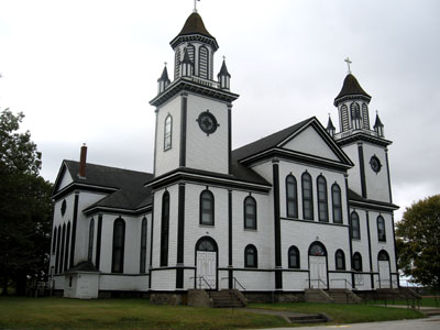
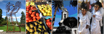
Ste-Anne, the oldest parish in Nova Scotia, dating back to 1799
Straight south from Yarmouth is a peninsula with a town called
Wedeport at the end. This is the location of la Butte-de-la-Croix,
a site that commemorates the first mass after the return of the
Acadians, held in 1769. Acadians were expelled
in several waves by the English between 1755 and 1763 and deported
to numerous destinations across eastern North America, the Caribbean
and even back to France during an extended period of ethnic cleansing.
Some of the French Acadian settlers returned to Nova Scotia, and
the Wedgeport location in particular is a symbol of Acadian courage
and perseverance.
East of Wedgeport are the Tusket Islands, about 365 islands, peninsulas,
inlets and bays that make up an intended coastline. The Bay of Fundy’s
tides have a big impact on this area, and salt water travels 24
km kilometers (15 miles) upriver on tides that are about 4 metres
(13 feet high). The islands vary in size from a few meters to half
a kilometer in length. This area was first settled by Acadian French
settlers and to this day French dialects and customs survive in
this area. Today there are thousands of “shanties”,
small tiny cottages, while in the past this area also featured large
fish factories and lobster canneries. Sea kayakers looking for bird-watching
and island hopping opportunities love this area.
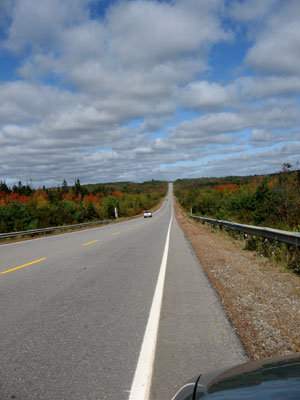
Driving along Highway 103
The Pubnico region comprises three different sections: West Pubnico,
with an almost exclusively French-speaking population, Pubnico proper
with primarily Anglophone residents, and East Pubnico, again occupied
mostly by French speakers. French Acadian settlements go back to
about 1614. Today, the local population mostly makes a living from
the fishing industry, which includes first and foremost lobster,
scallops, herring, haddock and cod. Not only is Pubnico considered
to be the oldest village which, in Acadia, is still occupied by
the Acadians, but it is also the oldest village in Canada still
occupied by the descendants of its founder. Since February of 2005
renewable energy is being produced at Pubnico Point. 17 interconnected
wind turbines generate about 100 GWh a year.
Further east along the shoreline is Cape Sable Island, the most
southerly point in Atlantic Canada. This small, low sandy island
is the location of about 1800 recorded shipwrecks since 1676. It
took until 1861 for the first light house to be constructed on Sable
Island, and in 1876 a steam-whistle fog alarm was added. Even since
then ships continue to run aground in this foggy, harsh marine environment,
but the loss of life has been low.
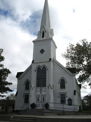
Saint Matthews United Church
The next major town along Highway 103 is Barrington which also
claims to be the Lobster Capital of Canada. The area around Barrington
features a variety of fishing villages, museums and heritage buildings.
Not far outside Barrington a major mystery awaits: just southwest
of the town is the Shag Harbour UFO sighting area, location of a
purported UFO crash on October 4, 1967. At least eleven people reported
seeing a low-flying lit object heading towards the harbour, accompanied
by a whistling and then a crashing sound when the object hit the
water. A search and rescue operation did not turn up any evidence
of a crash, and no aircraft were reported missing. A secretive military
expedition discovered some foam-like debris, and one military witness
stated that there were actually two objects, one possibly trying
to assist the other. To this day the Shah Harbour UFO Crash is an
unsolved mystery.
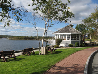
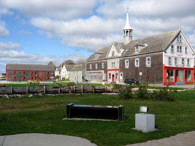
The tourist office right next to Shelburne's waterfront
The town of Barrington itself features a recently constructed walking
trail along the bay. The Barrington Woolen Mill, dating back to
1882, was an active mill until 1962 when it ceased production and
became a museum in 1968. Wool sheared from sheep who were grazed
on the various surrounding islands were processed in this turbine-driven
mill that saved Nova Scotian women endless time in terms of washing,
spinning and weaving wool at home.
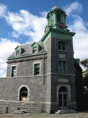
Shelburne's Post Office and Customs House
My drive continued inland towards Shelburne, my next destination.
Shelburne was first settled in the spring of 1783 when 5000 settlers,
United Empire Loyalists, arrived here from the middle colonies in
America. By 1784, the town was the fourth largest in all of North
America, larger than Halifax, Montreal or Quebec City. Fishing,
shipbuilding and the lumber industry formed the economic mainstays
of the area. Many descendants of these Loyalists still live in the
area today.
Black Loyalists also settled in this area when the Royal Governor
of Virginia awarded freedom to any slave who would escape from a
rebel slave master and fight alongside the British Loyalists. More
than 300 Blacks joined the Loyalist forces and formed the Ethiopian
Regiment. In total about 100,000 slaves took refuge behind British
lines.
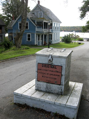
The public well on Ann Street in Shelburne
In 1782 when Americans were winning the war, the British prepared
to depart. During this time some Blacks were recaptured while others
resettled in Florida, the West Indies and Canada (or rather British
North America, as it was called at the time). The largest group
of Black settlers, about 3500 people, were transported to Nova Scotia
and New Brunswick. Birchtown, just a few kilometers west of Shelburne,
became the largest settlement of free Blacks outside of Africa.
However, of 649 families only 184 received the promised crown land
grants.
On the right: the George A. Cox Warehouse, on the left the Dory
Shop
The Black Loyalist Heritage Society Museum in Birchtown commemorates
the Black Loyalist settlers who founded the largest free Black settlement
in all of North America. Unfortunately the museum was closed when
I travelled through the area. However, I did have a chance to explore
some of the Shelburne area's other museums. This small town has
a large museum complex on the waterfront which forms one of the
best natural harbours in the world. I drove down on Main Street
which features Victorian architecture as well as a large Romanesque Revival building constructed in 1908 from local granite which used
to be the Post Office and Customs House. Coming down Ann Street
I noticed a well that was located right in the middle of the road,
an example of the community wells that were typical in this area.
Then I headed down to Dock Street on the Waterfront, formerly the
centre of Shelburne’s commercial activity. I was immediately
struck by a large wooden structure, dating back to 1902 which used
to be the store and warehouse of George A. Cox, a prominent merchant
who built his own vessels. Tucked in behind it is Guild Hall, a
set from the move “A Scarlett Letter”. This building
was constructed to reflect 17th century architecture.
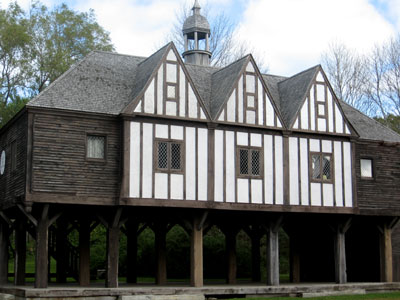
Guild Hall, constructed for the movie "A Scarlett Letter"
Along the waterfront is the John C. Williams Dory Shop, a working
museum that demonstrates the craft of dory building. Dories were
small wooden fishing boats that were very popular in the around
the turn of the 20th century and were purchased by Nova Scotian
and American fishing captains. This shop dates back to 1880, and
in its heyday five to seven men produced 350 dories a year.
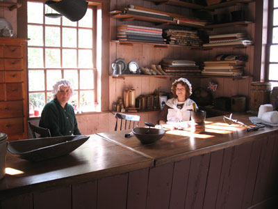
Historical interpreters in the Ross-Thomson House
On the other side of the street is the restored Ross-Thomson House
and Store. George and Robert Ross were merchants, trading pine boards,
codfish and pickled herrings for salt, tobacco, molasses and dry
goods. The store actually closed in the 1880s, was restored to its
1820s condition and today operates as a museum. I took a quick tour
through the Ross-Thomson House which provides a good idea of the
living conditions of the early Loyalist settlers.
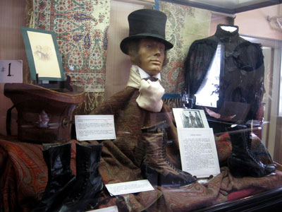
Fashions of long ago in the Shelburne County Museum
Right in this complex is the Shelburne County Museum which houses
one of the oldest fire pumpers in all of North America. It also
features exhibits on shipbuilding and local Loyalist history. History
buffs can access newspapers and court records from the 18th to the
20th century, all saved on microfilm, and genealogy records of Shelburne
County families are also available.
Shelburne is a very scenic town with numerous unusual heritage
buildings located on the waterfront and on various other streets
leading up from the water. I wish I had had a bit more time to explore
this town, but my schedule was getting tight. I wanted to continue
on eastwards along the Lighthouse
Trail to make sure I arrived before sunset so I would be able
to see the town of Lunenburg before
dark, one of Nova Scotia’s favourite destinations.
Useful books about travel to Nova Scotia:
Related articles:
My five whirlwind days in Nova Scotia
Acadian
history at the Grand Pré National Historic Site
400 years of history at Annapolis
Royal
Port-Royal, a French habitation from 1605
Dinner at the Garrison House
in Annapolis Royal
The Annapolis Royal
Graveyard Tour
The Garrison House Bed and Breakfast
Exploring the Evangeline Trail from
Annapolis Royal to Yarmouth
Learning about Mi'kmaq heritage at the
Bear River First Nation Heritage and Cultural Center
Victorian heritage in Yarmouth
The MacKinnon-Cann Inn: Where Home
and Garden Television meets the Travel Channel
Yarmouth explained - the Yarmouth
County Museum
My car is in the ditch in Chebogue
River
The Lighthouse Trail from Yarmouth
to Shelburne
The Lighthouse Trail from Shelburne
to Lunenburg
The Town of Lunenburg - a UNESCO World Heritage
Site
An interview with the owners of the
Lunenburg Inn
The Lighthouse Trail from Lunenburg to
Halifax via Mahone Bay and Peggy's Cove
Arrival in Halifax and a stunning
musical performance - DRUM!
A Halifax city tour, the city's
connection to the Titantic and the 1917 Halifax Explosion
Exploring the Halifax Harbourwalk and
Pier 21 - Canada's immigration museum
A ferry trip to Dartmouth and saying
goodbye to Halifax
An interview with Pier 21 -
Canada's immigration museum
Helpful links for travel to Nova Scotia:
Tourism
Nova Scotia
Destination
South West Nova Scotia
Halifax Tourism
|